Traveling to and from New York by land in the 1700s was not for the faint of heart. The city of about 18,000 people was generally huddled around or below Wall Street, and the few roads that ran north through the wilds of Manhattan were primitive and hazardous.

To help guide hearty travelers by foot, horseback, and stagecoach, city officials installed a series of stone mile markers on the Old Post Road that let people know how far they were from city hall.
The Old Post Road, or King’s Highway, as it was known before the Revolutionary War, followed a preexisting Native American trail into today’s Westchester and then up to Albany or Boston. As its name indicates, the road was used for mail delivery, and Postmaster Benjamin Franklin himself supervised the placing of the mile markers.
Over the years, the mile markers—the first at Rivington Street and the Bowery, and the last in the Bronx near Spuyten Duyvil, according to a 1915 document from the City History Club—disappeared from the streetscape.

Yet one of these “battered and broken milestones,” as an 1895 Sun article put it, still exists today in Upper Manhattan. Amazingly, it’s embedded in a stone retaining wall just steps from Broadway between 211th and 212th Streets.
The milestone, which used to tell travelers that they were 12 miles from the main city, has been part of this stone wall (photo, about 1910) since the end of the 19th century.
How did it end up here? Well, this wasn’t the milestone’s original exact location. According to the Sun, it used to stand on a nearby road called Hawthorne Street, which is the former name of 204th Street.
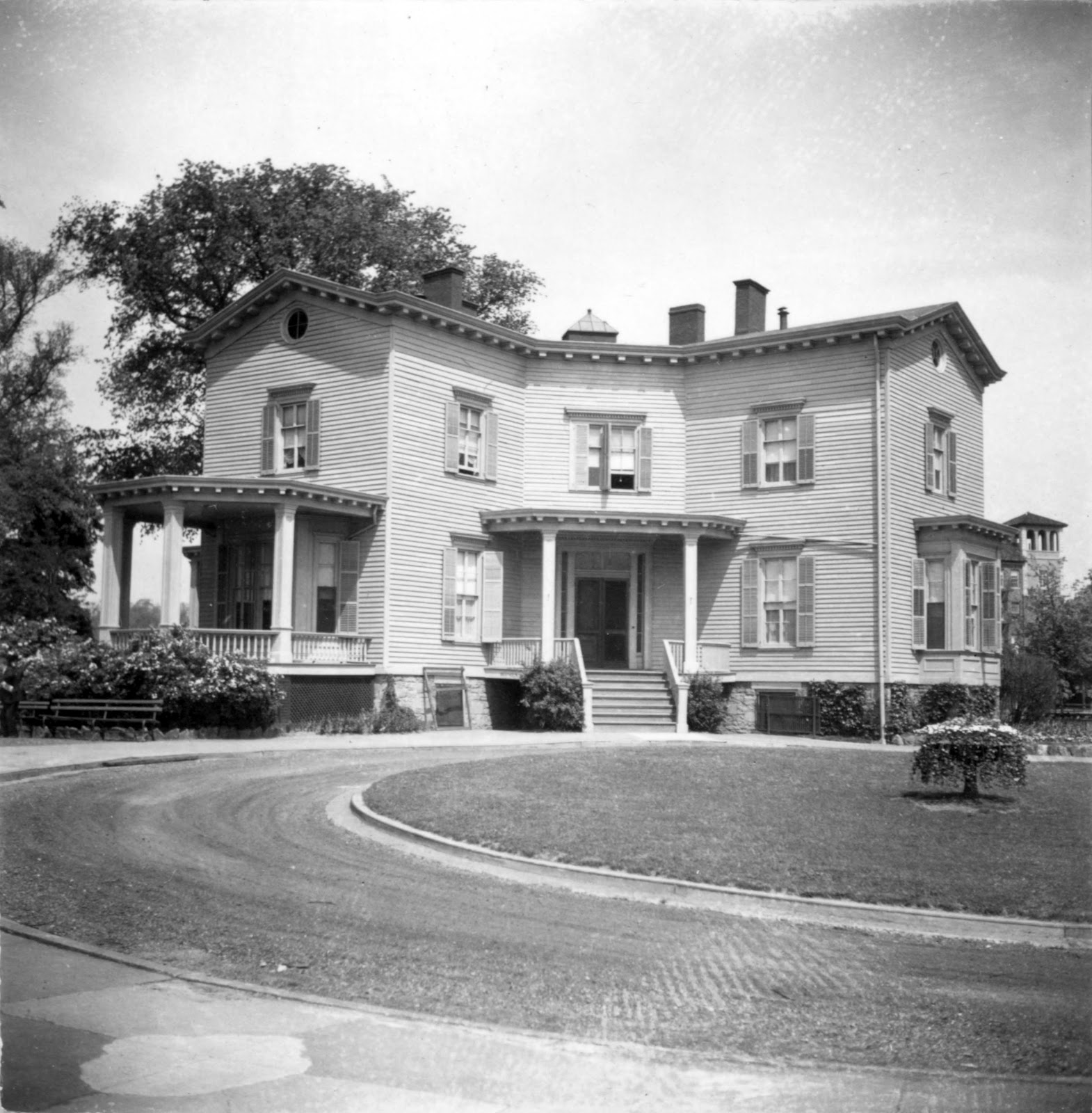
When construction crews were building roads and otherwise modernizing Inwood, they came across the mile marker that had outlived its purpose. William Isham, a wealthy leather merchant and banker with a nearby estate and mansion (above), took the mile marker and had it embedded into the wall.
“Mr. Isham had the stone marker moved and installed in the wall next to his gate when it was tossed aside by road workers on Broadway,” explains NYC Parks.
“When roadway workers were removing a red sandstone mile marker, William Isham had it installed at the right side of his entrance gate on Broadway,” echoed the Historic Districts Council.
After Isham’s death, his family donated the land from his estate, including the retaining wall with the mile marker, to the city in 1911 to create Isham Park.
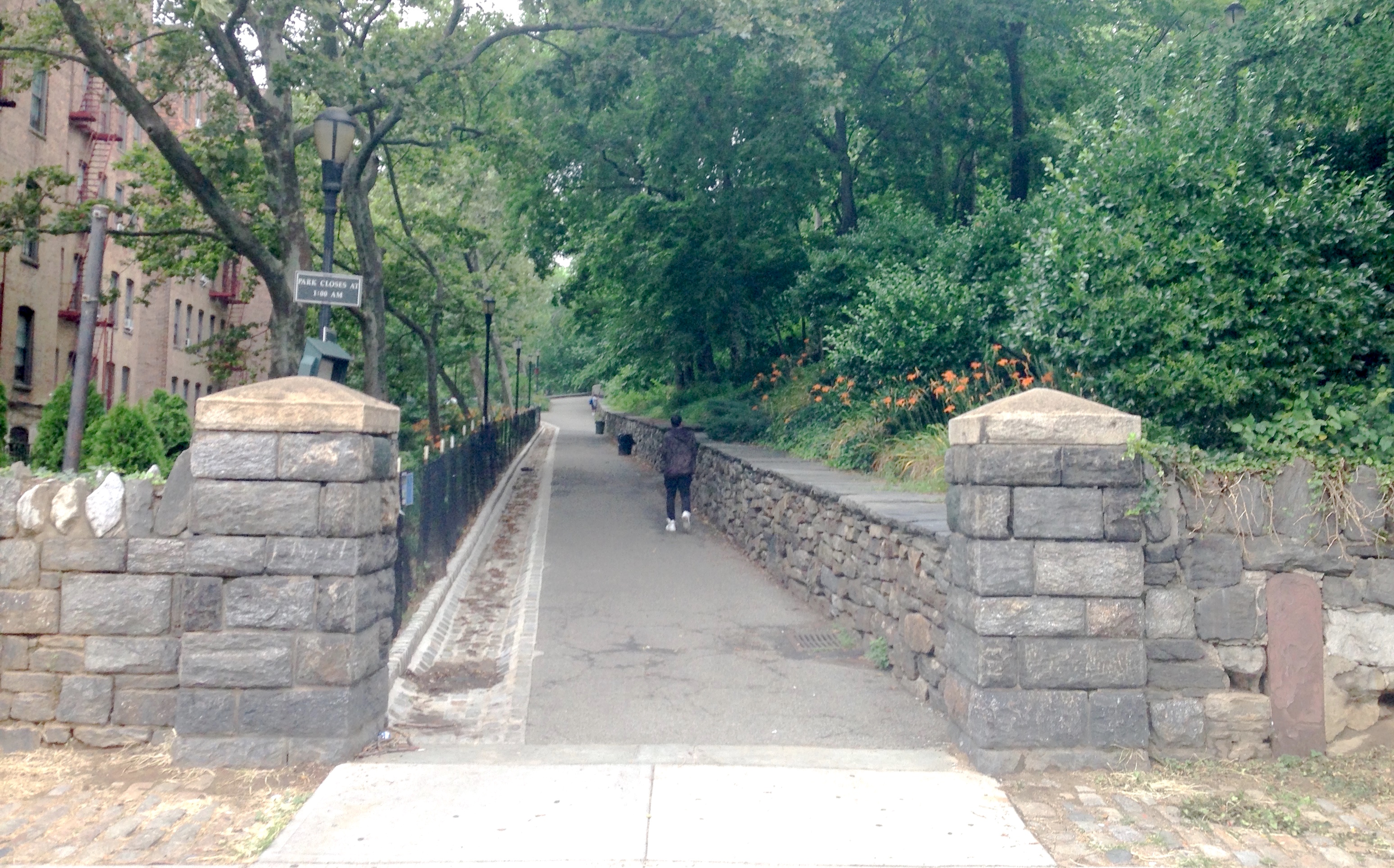
Sadly the 12-mile marker has lost its inscription. But it’s still an amazing remnant of the early days of Gotham, when getting far out of the main part of town could be treacherous and disorienting.
Though it’s the only milestone technically on a Manhattan street, there’s at least one other Old Post Road mile marker preserved in Manhattan: the 11-mile marker. It’s on the grounds of the Morris-Jumel Mansion on 160th Street near St. Nicholas Avenue and is noted with a small plaque.
Brooklyn, on the other hand, has its own mile marker relic still visible on a street. (Or at least it was several years back.) A stub of granite with the number 3 carved into it is on Ocean Parkway and Avenue P. That’s 3 as in three miles to Prospect Park, where Ocean Parkway begins.
[Top image: Wikipedia; second image: New-York Historical Society; third image: NYC Parks via Volunteers for Isham Park; fourth image: Wikipedia]
Tags: Isham Park Mile Marker, Mile Marker Colonial New York City, Mile Marker Inwood, MIle Markers in New York City, Milestones of New York City, Milestones on Old NYC Roads, New York in the 18th Century

September 6, 2021 at 8:31 am |
For more on another now long gone marker in Manhattan and associated oddities: https://newyorkwanderer.com/a-miners-lantern/
September 6, 2021 at 2:56 pm |
Thank you Ben, always enjoy your NYC research and writing, and what a wonderful photo you’ve found.
September 6, 2021 at 4:19 pm
My pleasure!
September 6, 2021 at 8:40 am |
Interesting to learn that W.204th street was once called Hawthorne Street. I live on nearby Cooper Street. Were these intersecting streets named after the early 19th century authors, and were there other literary street names here in Inwood?
September 6, 2021 at 2:57 pm |
I wish I knew for sure, but with a Hawthorne and Cooper Streets so close to each other, I suspect there was a literary-minded street namer at work.
September 6, 2021 at 9:02 am |
There was a Boston Post Road mile marker embedded in an old AT&T building in New Rochelle at the corner of Huguenot and Lawton streets. Massive urban renewal took that building a few decades ago and I have no idea if the stone survived, but the inscription was still visible last I saw it and was written by the same stone cutter (same “handwriting”).
September 9, 2021 at 10:49 am |
Paul – there are two in Pelham near me (South End).
September 6, 2021 at 10:21 am |
I happen to live on Seaman Ave (named for John Seaman, who had a much bigger mansion and estate that Isham several blocks north) at the end of W. 204th Street, formerly Hawthorne. I can’t recall the source, but the namesake of Hawthorne was not Nathaniel, but I believe it was some local minister or other prominent figure. Cooper, though, was in honor of James Fennimore. The site Inwood.net is a fount of information about this area, including this mile marker and much more. For more on street names – https://myinwood.net/inwood-street-names/ It does not back me up on Hawthorne, but it doesn’t contradict it either.
September 6, 2021 at 2:58 pm |
Thanks Giovanni, and yes, for all things Inwood, I encourage everyone to definitely check out myinwood.net.
September 7, 2021 at 8:10 pm |
This is fascinating. Thanks!
September 8, 2021 at 7:18 pm |
Great article, and I hate to pick nits, but the line: “… just steps from Broadway & 213th Street” was making me insane! lol
I looked and looked and looked and looked on AppleMaps, but I *just* couldn’t nail down where the exact entrance way was.
Finally, I just said the heck with it and decided to traverse the entirety of the Broadway-facing edge of Isham Park ….
Eureka!! The milestome is, in fact: just steps away from Broadway & **211th Street**. To be exact, it’s on the Downtown/West side of Broadway, directly across from 4986 Broadway/”CocinaLatina RESTAURANT”. Thank you! 🙂👍🏻
September 9, 2021 at 12:05 am |
This is fascinating. Thanks.
A shout out to @acrossthecurve for tweeting your posts.
BTW, Google maps shows that the Mile Marker is closer to the W 212th entrance.
September 9, 2021 at 12:50 am |
Thank you Canada and Cary for pointing out the correct street! Fixed the copy to reflect that.
December 29, 2021 at 12:08 am |
The house I grew up in had one at the end of our property in the stone wall. Rt 35 and Mead st in Westchester County. I think rt 35 is old post road. It read fifty miles to NYC. Hope it is still there. It was on mead street side right in between the two driveways.