Archive for the ‘Bronx and City Island’ Category

The unusual beauty of a 1908 row house “oasis of tranquility” in the Bronx

April 3, 2023

When you think of the Bronx, districts of tidy single-family attached row houses probably don’t come to mind. And that makes sense, considering the late start this northernmost borough had in terms of urban development.

The Bronx still maintained a sizable number of rural areas (and large estates owned by the wealthy) within its borders when it was annexed to New York City in stages from 1872 to 1895. The borough was too spread out, and had too few people, to build the kinds of brownstone and townhouse rows that urbanized Manhattan and Brooklyn throughout the 19th century.

But after a population boom in the early 1900s, as well as the opening of the New York City subway, row house development did come to some parts of the Bronx—including Hunts Point, when 42 two-story dwellings lining the north and south sides of Manida Street hit the market.

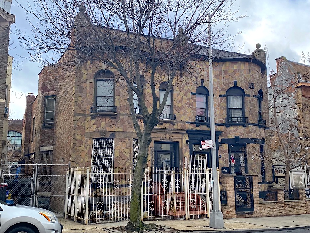
Instead of the brownstone or limestone homes typical of large parts of Manhattan and Brooklyn, the row houses along this stretch of the newly developed South Bronx are semi-detached dwellings in the Renaissance Revival or Flemish Revival style with bow fronts, stepped parapets, and other whimsical architectural touches.

These houses, situated on a single block between Garrison and Lafayette Avenues, make up the Manida Street Historic District. Made official in 2020, the new historic district joins others in the Bronx like the Bertine Block in Mott Haven and a section of Morris Avenue near the Grand Concourse.

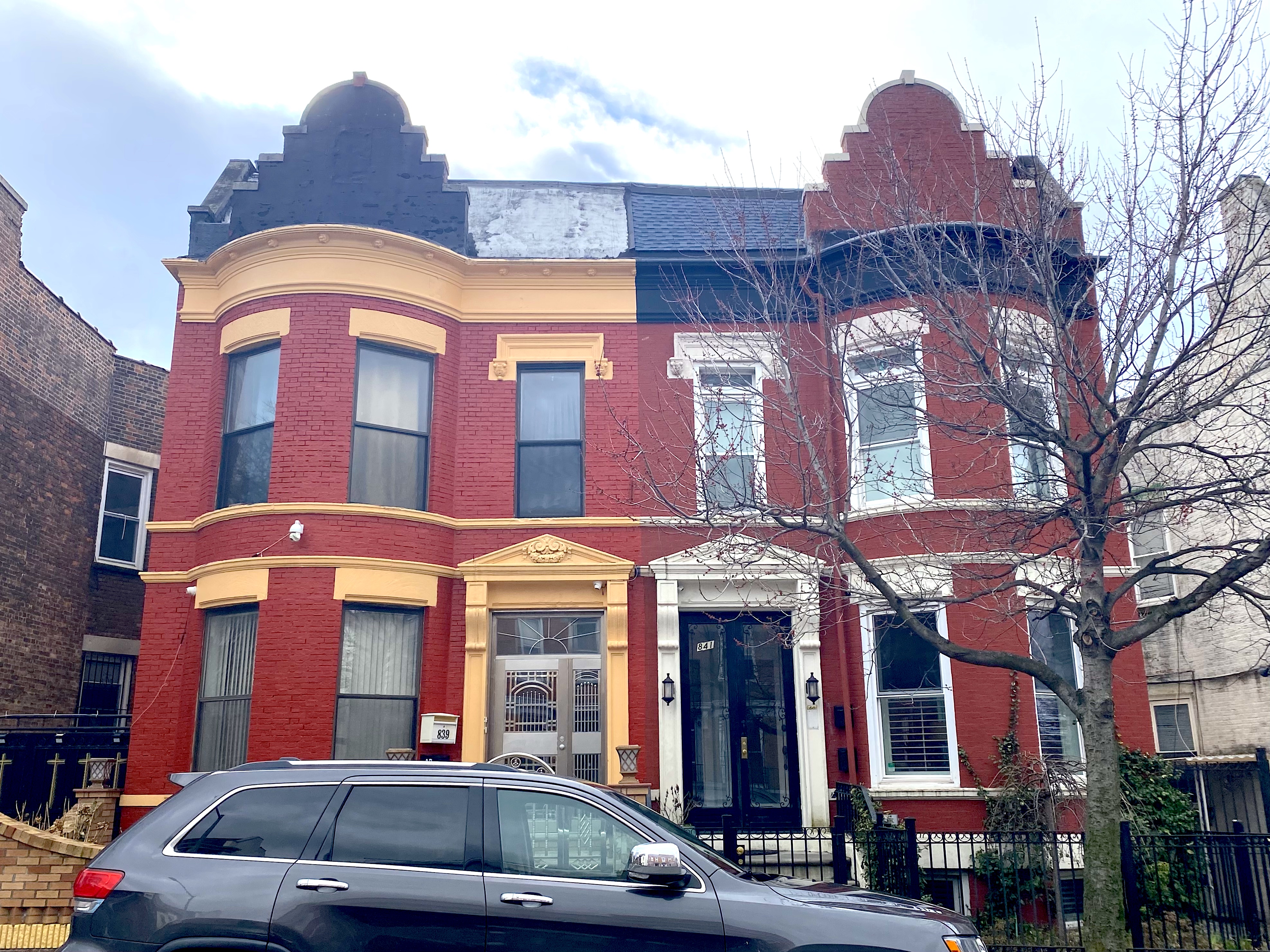
[Above, 839 and 841 Manida Street today; below, the two houses in 1939-1941]

“On both sides of Manida Street, the two-story and basement, semi-detached buildings feature mirror-image facades with rounded projecting bays, low stone stoops, simple cornices with steeply pitched parapets above, and ornamentation concentrated around the doors and windows,” stated the Landmarks Preservation Commission Report.

Designed by architects James F. Meehan and Daube & Kreymborg in 1908-1909, the row houses were built on speculation and advertised to potential buyers in a 1909 ad that ran in the New York Times, per the LPC report.

“These two-family houses are situated in one of the prettiest and most accessible areas of the Bronx,” the ad read. “They are in the heart of a district built up with some of the finest homes in the greater city.”

Who decided to buy one of these two-family row houses, which included the appealing option of renting one half of the house to another family and making back a little cash?

The first crop of owners were mostly immigrants, primarily Russian Jews, according to the LPC report. “In addition, there were several German households along the block, with a few Irish and Italian residents as well,” the report added.

Like much of the rest of the Bronx, Manida Street maintained its middle-class status as the 20th century continued. Residents worked as “tailors, teachers, diamond dealers, and leather merchants,” noted the report. Some worked at the nearby American Bank Note Company Printing Plant.

Demographics changed as the century continued, of course. While the Bronx’s fortunes turned, the row houses on Manida Street and the sense of a middle-class island in Hunts Point remained intact.

“In the 1970s, when the Hunts Point section of the Bronx became associated with drugs, crime, and prostitution, a group of bow-front row houses in the 800 block of Manida Street remained an oasis of tranquillity,” wrote the New York Times in 2010.

These days, the South Bronx is a place of redevelopment, and the Manida Street row houses are part of a protected historic district. Though many of the houses reflect the bad old days of the area—with bars over bay windows, metal fences, and ornamentation on the facades missing—there’s an unusual harmony and beauty to the quiet block.

Will it be the next Park Slope? Probably not—it’s just one slender street. But never say never.

[Third photo: NYC Department of Records and Information Services]

Two early Bronx subway signs that still point the way “up town”

March 13, 2023

The blue and white tiles are obscured by decades of grime, edged out of the way by brighter yet featureless subway signage at a Bronx IRT station.

I tried my best to brighten them up digitally and make them look as delightful as they probably did in 1919, when this station, at Hunts Point, opened. No camera filter did them justice. So try to overlook the filth and feel the magic of seeing “Up Town” spelled out as two separate words.

Unfortunately there were no corresponding “Down Town” signs in this station; they were probably damaged years ago, then carted away by the MTA.

But you can still come across similar olds-school tiled signs in other early stations—like the Chambers Street IRT on the West Side, which features bright, clean “Up Town” and “Down Town” directionals.

The city’s most neglected war memorial might be this granite marker in the Bronx

March 6, 2023

You can barely walk through a New York City park or square without coming across some kind of war memorial, and I consider that a good thing.

Sturdy doughboy statues, proud eagle sculptures, sedate bronze plaques—these monuments don’t just pay homage to the dead but connect us to different eras in Gotham’s past. They remind us, even for a passing moment as you hurry to catch the bus, about the human toll of combat.

But occasionally you encounter a war memorial that feels not just forgotten but almost actively neglected, so battered by the elements over time that it’s become more of a receptacle for litter, not a source of reflection.

That’s the case with this granite, five-foot marker outside the Hunts Point 6 train station in the Bronx. Intended to honor the Hunts Point natives who lost their lives in World War I, it sits on a sidewalk island once known as Crames Square, for a local resident named Charles Crames who was killed in the Great War.

“To the men of Hunts Point who gave their lives in the World War 1914-1918,” a simple inscription at the top reads like a scroll between two carved ribbons.

This granite marker didn’t start out so unloved. “Three thousand residents of Hunt’s Point [sic] attended the unveiling of a seven-ton granite memorial to World War dead from that part of the Bronx,” wrote the New York Times in a small writeup on May 23, 1938.

The afternoon ceremony went from 2:30 to 4:30, and it was preceded by a parade “of civic organizations, school children, Gold Star mothers and veterans and auxiliaries of the American Legion and Veterans of Foreign Wars,” continues the Times.

Buglers played taps, and a local official told the reporter that “the purchase of a bronze eagle three feet in height was being considered by the civic association to complete the monument.”

Eighty-five years after the unveiling, Crames Square no longer honors a Great War casualty because it no longer exists. This busy spot is now known as De Valle Square, after a Cuban-born priest who led the nearby Bronx parishes at St. Anselm’s and St. Athanasius in the 1970s and 1980s.

The granite monument itself hasn’t been erased, but there’s an empty circle which perhaps held the bronze eagle the civic leader at the parade mentioned to the New York Times reporter.

Waiting for Thanksgiving dinner at a Bronx orphanage

November 21, 2022

Thanksgiving in early 20th century New York City wasn’t just celebrated in private homes and expensive hotel restaurants. Institutions of all kinds across Gotham also honored the holiday with their own commemorative dinners.

Hospitals, facilities for the poor, sick, and aged, and even city prisons served up a special Thanksgiving meal—usually along with speeches by important guests and often religious sermons.

Orphanages also celebrated Thanksgiving. This photo (above) shows more than 100 young residents sitting at long, linen-draped tables inside the girls’ dining room at the Roman Catholic Orphan Society in the Bronx. The orphanage was built in 1902, relocated from an older building on Fifth Avenue in Midtown.

A boys’ dining room operated in a building next door. Together, both the girls’ and boys’ buildings could house up to 1,600 residents at a time, according to nycago.org.

These uniform-clad, unsmiling girls look like they’re on their best behavior. I wish we knew exactly what their Thanksgiving menu offered…and what their adult lives were like.

You won’t find this handsome orphanage (above, in 1914) in the Bronx anymore. By the 1920s, thanks to a sizable reduction in the number or orphan residents, both buildings were abandoned and sold. The Bronx VA Hospital took its place.

[Photos: New-York Historical Society]

The story of how the Bronx got its name

September 23, 2022

Manhattan is a corruption of the Native American word Mannahatta; Staten Island derives from Staaten Eylandt, named by the Dutch. Brooklyn is the anglicization of the Dutch village of Breukelen, and Queens comes from English Queen Catherine of Braganza, who happened to be on the throne in the 1680s, when England was divvying up the former New Netherland.

But the origin of the name for New York City’s northernmost borough, the Bronx? That’s a longer story of an immigrant and his prosperous farm in the wilderness of the New World.

It all starts in 17th century Europe with a man named Jonas Bronck. The consensus seems to be that Bronck was Danish, though some historians believe he was from Sweden. Others contend he was from a Dutch Mennonite family driven to Denmark by religious persecution.

A 1639 map of New Netherlands, the year Jonas Bronck arrived

Whatever his native country was, Bronck made his way to Holland. With his wife and a group of other immigrants, he boarded a ship to New Amsterdam in 1639. “The ship also carried implements and cattle for commencing a plantation on a large scale,” states the 1916 text Scandinavian Immigrants in New York, 1630-1674.

Upon arrival, Bronck purchased 500 acres from local Native Americans (or from Dutch leaders; sources differ) in today’s Morrisania or Mott Haven neighborhood, on the other side of the Harlem River. He cleared the land and built a stone house “covered with tiles,” a barn, several tobacco houses, and barracks for his servants, per Scandinavian Immigrants in New York.

The view from Broncksland a century after Jonas Bronck’s death

“The purchase price was two guns, two kettles, two adzes [a tool similar to an axe], two shirts, a barrel of cider, and six coins,” states a New Yorker piece from 1939. “His house stood where the N.Y. Central 138th St. station is now, just north of Harlem River.”

In sparsely settled New Netherland, Bronck grew tobacco, wheat, and corn. He also raised cattle and hogs, in “numbers unknown running in the woods,” according to a 1903 edition of the Journal of the New York Botanical Garden.

In 1908, John Ward Dunsmore portrayed the signing of the peace treaty at Bronck’s house

His farm must have been a success. The Broncks furnished their house with fine bed linens, table cloths, alabaster plates, silverware, and a library of religious and historical books in both Danish and German. It was inside this finely furnished house in 1642 where a peace treaty was signed between Native Americans and Dutch colonists (which didn’t last very long, needless to say).

Bronck’s time in his namesake borough was short. He died in 1643, and his wife quickly remarried and moved upstate. Despite his demise, the land where he built his farm was already known as Bronck’s Land, and the river north of his property was referred to as the Broncks’ River.

The South Bronx in the 19th century, with the High Bridge in the distance

Eventually, the entire borough—annexed into the city of New York in stages in the 19th century—became the Bronx at the time of consolidation in 1898. What’s with “the” in the borough’s name? “The” is a simply a holdover from when Broncks meant the river.

[Top image: MCNY, F2011.33.687; second image: Library of Congress via Wikipedia; third image: University of Michigan Library Digital Collections; fourth image: Wikipedia; fifth image: NYPL]

A peek inside a 1946 Yankees program—and the New York brands that advertised inside

April 25, 2022

I have no idea what a Yankees program looks like today. But I do know what it looked like in 1946, when the Bronx Bombers hosted the Cleveland Indians either in late April/early May, June, or August of that postwar year.

Strangely, the 16-page program doesn’t say when the series takes place. But it mentions the upcoming All-Star Game at Fenway Park, so it must have been before July.

The lineup of legendary players to take the field that day included Phil Rizzuto, Joe DiMaggio, and Bill DIckey, with Bill Bevens and Spud Chandler listed as pitchers. More interesting to me are the ads throughout the 16-page program—like Ruppert Beer.

The Ruppert ad for this Yorkville-brewed beer isn’t much of a surprise because the Yankees were owned by Jacob Ruppert from 1915 until his death in 1939. A plaque recognizing his devotion to his team stands in Yankee Stadium’s Monument Park.

I’ve never heard of Major’s Cabin Grill. It’s on 34th Street, a long subway ride from Yankee Stadium, but why not? I like the warning about betting and gambling at the stadium.

I’m glad to see Schrafft’s make an appearance in the program; the restaurant chain famous for its ice cream was highly popular at the time. Apparently the ice cream bars they sold to fans at the stadium were in short supply.

The Hotel New Yorker today may not be a five-star kind of place, but it had a better reputation in the mid-20th century. This is the first time I’ve seen it described as a “home of major-league ball clubs.”

Here’s the actual scorecard, plus some fun ads on the sides—especially for the famous Hotel Astor rooftop. At one time, this was a glamorous place for dining, dancing, and catching a cool breeze in a city without air conditioning.

Two 1930s tile signs point the way in a Bronx subway station

January 10, 2022

The B and D stop at Fordham Road and the Grand Concourse in the Bronx isn’t a particularly stunning station.

Opened as part of the IND Concourse Line, the station made its debut during the Depression year of 1933, when transit officials probably weren’t thinking of devoting extra money to beautify an outerborough subway station.

But the station does have two old-timey touches that give it a bit of loveliness and humanity: tile signs letting passengers know which way to go depending on what side of the Grand Concourse—the Bronx’s answer to the Champs Elysees—they needed to get to.

Vintage subway signage like this can still be found on some platforms. Here’s an example at Chambers Street on the West Side, and another at the Cortlandt Street R train stop telling riders where to go to get to the “Hudson Tubes.” And of course, the stop at 14th Street and Sixth Avenue is a treasure trove of forgotten subway signage.

What life was like with the elevated train roaring outside your window

November 15, 2021

“The elevated railroad, perpetually ‘tearing along’ on its stilted, aerial highway, was ‘an ever-active volcano over the heads of inoffensive citizens,” wrote one Australian visitor who came to New York in 1888.

38 Greenwich Street in 1914

That description gives us an idea of the feel of Gotham in the late 19th century, when steam-powered (later electric) elevated trains carried by trestles and steel tracks ran overhead on Ninth, Sixth, Third, and Second Avenues.

The upside to the elevated was obvious: For a nickel (or a dime during off hours), people could travel up and down Manhattan much more quickly than by horse-drawn streetcar of carriage. New tenements, row houses, and entertainment venues popped up uptown, slowly emptying the lower city and giving people more breathing room.

Bronx, undated

The downside? Dirt and din. The trains and tracks cast shadows along busy avenues, raining down dust and debris on pedestrians. (No wonder Gilded Age residents who could afford to changed their clothes multiple times a day!) And then there was the deafening noise every time a train chugged above your ears.

Now as unpleasant as the elevated trains could be in general, imagine having the tracks at eye level to your living quarters. Life with a train roaring by at all hours of the night was reality for thousands of New Yorkers, particularly downtown on slender streets designed for horsecars, not trestles.

Allen Street north of Canal Street, 1931

“The effect of the elevated—the ‘L’ as New Yorkers generally call it—is to my mind anything but beautiful,” wrote an English traveler named Walter G. Marshall, who visited New York City 1878 and 1879.

“As you sit in a car on the ‘L’ and are being whirled along, you can put your head out of the window and salute a friend who is walking on the street pavement below. In some places, where the streets are narrow, the railway is built right over the ‘sidewalks’…close up against the walls of the houses.”

Second Avenue and 34th Street, 1880s

Maybe these unfortunate New Yorkers lived in a tenement before the trains came along, and they couldn’t find alternative housing after the elevated was built beside their building. Or perhaps in the crowded city teeming with newcomers at the time, a flat next to a train was the best they could find with what little they had to spend.

Wrote Marshall: “The 19 hours and more of incessant rumbling day and night from the passing trains; the blocking out of a sufficiency of light from the rooms of houses, close up to which the lines are built; the full, close view passengers on the cars can have into rooms on the second and third floors; the frequent squirting of oil from the engines, sometimes even finding its way into the private rooms of a dwelling-house, when the windows are left open—all these are objections that have been reasonably urged by unfortunate occupants of houses who comfort has been so unjustly molested….”

Allen Street, 1916

Eye-level elevated trains continued into the 20th century, with above ground subway tracks as well as older els making it more likely that New Yorkers could find themselves with a train rattling and shaking their windows.

And it’s still an issue today, of course, even with those original el lines long dismantled. Tenements and apartment buildings near bridge approaches, tunnel entrances, and above ground subway tracks are still at the mercy of mass transit in a city still of narrow streets, single pane windows, and rickety real estate.

Convergence of the Sixth Avenue and Ninth Avenue Els, 1938

[Top photo: MCNY x2010.11.2127; second photo: New-York Historical Society; third photo: MCNYx2010.11.4; fourth photo: CUNY Graduate Center Collection; fifth photo: MCNY MNY38078; sixth photo: MCNY MN11786]

The unromantic tale of Bronx’s Valentine Avenue

February 10, 2020

Old New York had many romance-themed paths and street names.

18th century Chelsea used to have a meandering road called Love Lane; some city parks also had Lovers’ Lanes. And Brooklyn Heights still has its own Love Lane, a sweet former mews off Henry Street.

But with Valentine’s Day coming up this week, it’s only fitting to recognize the Bronx’s long, bustling Valentine Avenue.

Valentine Avenue really isn’t all hearts and flowers, unfortunately. This crowded corridor runs alongside the Grand Concourse from Fordham to Bedford Park, a long stretch of small apartment buildings and neighborhood shops.

The street didn’t get its name for any romantic reason, either.

Valentine Avenue likely honors Isaac Valentine, a young blacksmith and farmer who built a house near the former Boston Post Road in the village of Fordham in 1758—when the Bronx was a collection of farming hamlets and not even part of New York City.

Even after part of the Bronx joined New York, it was still quite rural—there was even a spring named after Valentine, seen in the photo above in 1897.

Valentine didn’t stay in his house for long. During the Revolutionary War it was used by American General William Heath and his troops, according to the Bronx Historical Society.

The war ruined Valentine, and in 1792 his house was purchased by Isaac Varian. Today, the Valentine-Varian House still stands, a monument to the old agrarian Bronx and the borough’s second-oldest house. (Above)

Speaking of Valentine, there was a Valentine Street in Queens…but it looks like it was renamed 66th Street at least a century ago and doesn’t appear on Google maps. If it does still exist, I’d like to know!

[Second photo: New-York Historical Society; third photo: Wikipedia]

Beauty and humanity in a Third Avenue El film

December 9, 2019

In 1955—before the shutdown of the Third Avenue El between Chatham Square and East 149th Street in the Bronx—a filmmaker named Carson Davidson took his camera up to a lonely platform and into one of the mostly empty trains.

With just weeks to go before the train and this main portion of the elevated would be trucked to the scrapyard, Davidson and a group of actors shot a haunting Impressionist short film.

The El may have been destined for the wrecking ball, yet Davidson’s film brings it alive—the iron spine of a city snaking between the tenements of Lower and Upper Manhattan and then over the Third Avenue Bridge into the Bronx.

The voiceless characters feel familiar, but they’re not cliches. A man sleeps, a couple plays cards. A stumblebum gets on near the Bowery and tries to wring one last drop out of a bottle of liquor. A little girl excitedly takes a seat.

Out the train windows we see the geometrical shadows of the railings on platforms. The camera turns to the train itself, a metal machine screeching and lurching high above sidewalks while a harpsichord plays as a soundtrack.

During the ride Davidson captures a street cleaner, faded ads, puddles on paving stones, the Chrysler Building, laundry lines, the Harlem River, and a tugboat belching smoke as a swing bridge aligns itself so the train can keep going.

The Third Avenue El threads the characters’ stories, as does a coin caught in the floor of the train car. Each character tries and fails to grab it.

Finally at night, a young couple boards. Amid glimpses of a Horn and Hardart Automat sign and a movie marquee, the male half of  the couple picks up and pockets the coin.

A director and artist I know had this to add about Davidson’s Oscar-nominated short:

“Although the filmmaker is fascinated with mechanics and shapes, it is always softened by humanity, the sympathetic characters. It’s literally a day in the life of the El which ends, after all those geometrically composed images, romantically with the lovers getting the coin.”